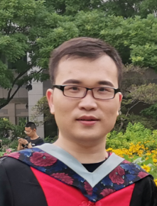
梁欣廉
Professor
Supervisor of Doctorate Candidates
Supervisor of Master's Candidates
Date of Birth:1980-03-09
E-Mail:
Date of Employment:2021-01-01
School/Department:State Key Laboratory of Information Engineering in Surveying, Mapping and Remote Sensing
Education Level:With Certificate of Graduation for Doctorate Study
Business Address:State Key Laboratory of Information Engineering in Surveying, Mapping and Remote Sensing
Gender:Male
Contact Information:xinlian_liang@hotmail.com
Status:Employed
Alma Mater:Aalto University
Hits:

Personal Profile:学习及工作经历: 2010.09 - 2014.06 内蒙古农业大学|测绘工程|学士|本科 2014.09 - 2017.06 山东科技大学|大地测量学与测量工程|硕士|研究生(硕士) 2017.09 - 2021.01 北京师范大学|地图学与地理信息系统|博士|研究生(博士) 2021.03至今 武汉大学测绘遥感信息工程国家重点实验室 武汉大学重点资助博士后 研究兴趣:基于激光雷达点云的森林环境信息感知与认知 个人成果与项目:以第一/通讯发表2区及以上SCI论文3篇。主持自主科研项目(探索类)1项,参与国家自然科学基金项目(面上)2项。 座右铭:但行好事,莫问前程 E-mail:shangshu_cai@whu.edu.cn
Education Level:Postgraduate (Postdoctoral)
Degree:Doctoral degree
Current Status:Graduated
Prof. Dr. Xinlian Liang received the Doctor degrees with honors in Geoinformatics from Aalto University, Espoo, Finland, in 2013. In 2016, he received a title of Docent at the University of Helsinki, Helsinki, Finland. He joined the Wuhan University in 2021. Previously, he was a research manager in the Finnish Geospatial Research Institute (FGI).
Dr. Liang's main research interest lies in the quantitatively understanding forest 3D structures, characteristics, and their roles in nature such as the carbon and nutrient fluxes, the energy and water cycles, as well as the biodiversity and climate changes. In past twenty years, he had collected rich experiences on forest digitization with a wide spectrum of technologies including the laser scanning, optical images, as well as multi- and hyper-spectral sensors, from terrestrial, mobile, UAV, aerial, and satellite perspectives.
His references in science are represented by a series of highly citied papers, e.g., ESI hot/highly cited paper (0.1% top cited paper in Geosciences, in ISPRS Journal 2016, first author; 1% top cited paper in Geosciences, in ISPRS Journal 2018, first author), Google scholar matrix paper (in IEEE TGRS 2012, first author), and most downloaded paper (in IEEE TGRS 2015, first author). He has an H-index 32 (ISI) and 40 (Google Scholar). Dr. Liang's publication list includes over 100 peer reviewed papers (90+ in ISI Web of Science). Since 2016, he has supervised 20+ Postdoc, PhD, and master students. Dr. Liang was listed in the World's Top 2% Scientists ranking by Stanford University in 2021 and 2022 (Top 1% in 2022).
Dr. Liang is actively involved in the international research community. He was the Chair of the Working Group III/1 'Thematic Information Extraction', the International Society for Photogrammetry and Remote Sensing (ISPRS), 2016-2022. Since 2022 he is chairing the Working Group III/1 'Remote Sensing Data Processing and Understanding'. He is the Associated Editor of Forest Ecosystems and Editor of Geo-spatial Information Science as well as Remote Sensing (all web of science listed). He is also the Guest Editor of Remote Sensing of Environment.
Personal website:https://scholar.google.com/citations?user=foWAGwYAAAAJ&hl=en&oi=ao