
王心宇
- 硕士生导师
- 出生日期:1991-12-01
- 电子邮箱:
- 职务:副教授
- 学历:博士研究生毕业
- 办公地点:武汉大学 信息学部 宇航科学与技术研究院 401室
- 性别:男
- 职称:副教授
- 所属院系: 遥感信息工程学院
- 学科:
摄影测量与遥感
王心宇,工学博士(通信与信息系统),遥感信息工程学院(宇航科学与技术研究院),副教授,博导,入选2019博士后创新人才支持计划。近年来,主持国家自然科学基金、国家重点研发计划子课题、慧眼行动等科研项目。获测绘科技进步一等奖、湖北省科技进步一等奖、IEEE WHISPERS 高光谱目标跟踪挑战赛冠军、IJCAI LandSlide4Sense 滑坡识别竞赛冠军、高光谱遥感影像智能处理行业应用大赛特等奖、全球开放数据创新应用大赛一等奖等学术奖励。在RSE、ISPRS P&RS、IEEE TGRS、IEEE TIP、IEEE TCYB、CVPR、ICCV、AAAI等高水平期刊与会议发表学术论文80余篇,获国家发明专利10余项,软件著作权4项,担任30余个国内外期刊的审稿人。
研究方向:围绕天-空-地新型遥感对地观测数据,研究高光谱、高空间分辨率遥感智能解译方法,服务于农林生态、自然资源、深空探测、工业视觉及智慧医疗等多领域应用。主要研究方向:
① 开放环境下的高光谱遥感智能处理
② 高分辨率农业遥感智能处理与应用
③ 边缘(卫星/无人机)平台实时处理
④ 遥感与环境健康监测应用
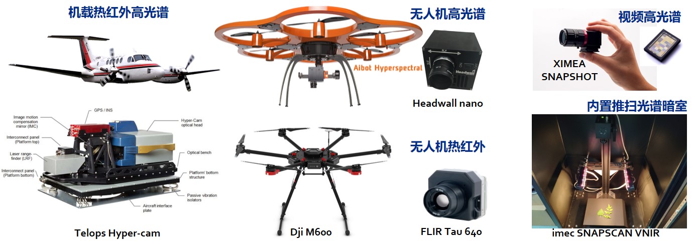
研究团队:RSIDEA研究组是由从事遥感方向研究的科研人员组建的一个学术研究组,学术指导为张良培教授(IEEE Fellow),负责人为钟燕飞教授,研究团队具备机载热红外高光谱相机、无人机高光谱相机、光谱暗室、快照式视频高光谱相机、红外-微光夜视相机、工业级服务器等先进设备,拥有良好的学术与科研氛围!
招生信息:欢迎遥感、计算机、电信、数学、测绘、资环等专业背景同学报考,欢迎本科生以大创形式提前进组学习!
(请发送个人简历至邮箱:wangxinyu@whu.edu.cn)
大型仪器设备
News
2026.04 耕地地块矢量化成果 “Towards Individual Agricultural Parcel Vectorization from VHR Imagery: A Coarse-to-Fine and Multi-task learning method”被摄影测量与遥感顶刊 ISPRS P&RS 接收!
2025.11 农村细窄道路制图成果 “Identifying rural roads in remote sensing imagery: From benchmark dataset to coarse-to-fine extraction network” 被摄影测量与遥感顶刊 ISPRS P&RS 接收!
2025.08 细粒度作物分类成果 “FineCrop: Mapping fine-grained crops using class-aware feature decoupling and parcel-aware class rebalancing with Sentinel-2 time series” 被摄影测量与遥感顶刊 ISPRS P&RS 接收!
2025.08 跨区域非农化变化检测成果 “CR-CLCD: A Cross-Regional Cropland Change Detection Framework” 被遥感应用权威期刊JAG接收!
2025.04 夜间多模态目标跟踪数据集成果 “NOT-156: Night Object Tracking using Low-light and Thermal Infrared” 被遥感权威期刊 IEEE TGRS 接收!
2025.04 全球农村道路基准数据集成果 “WHU-RuR+: A benchmark dataset for global high-resolution rural road extraction” 被遥感应用权威期刊JAG接收!
2025.02 高光谱遥感大模型成果 “HyperFree: A Channel-adaptive and Tuning-free Foundation Model for Hyperspectral Remote Sensing Imagery” 被计算机视觉顶会 CVPR 2025 接收!
2025.01 基于高光谱成像的心血管智能诊断成果“Noninvasive Oral Hyperspectral Imaging–Driven Digital Diagnosis”被医学TOP期刊Journal of Medical Internet Research接收!
2024.10 跨模态遥感异常目标探测成果 “Learning a Cross-modality Anomaly Detector for Remote Sensing Imagery ” 被图像处理顶刊 IEEE Transactions on Image Processing 接收!
2024.09 农作物制图更新成果 “CROPUP: Historical products are all you need? An end-to-end cross-year crop map updating framework without the need for in situ samples” 被遥感顶刊 Remote Sensing of Environment 接收!
2024.08 多模态眼底异常检测定位成果 “Adapting the Segment Anything Model for Multi-modal Retinal Anomaly Detection and Localization” 被信息融合领域权威期刊 Information Fusion 接收!
2024.07 实例级遥感影像异常分割成果 “Segmenting Remote Sensing Anomalies at Instance-level via Anomaly Map Guided Adaptation” 被遥感权威期刊 IEEE TGRS 接收!
2024.06 无监督自适应高光谱去噪成果 “Unsupervised Adaptation Learning for Real Multi-Platform Hyperspectral Image Denoising” 被自动化与控制系统领域权威期刊 IEEE TCYB接收!
2024.05 农田非农化变化监测方法与基准数据成果 “Identifying cropland non-agriculturalization with high representational consistency” 被摄影测量与遥感权威期刊 ISPRS P&RS 接收!
2024.05 联合波段选择的高光谱PU学习分类成果 “PU-KBS: A Robust Positive and Unlabeled Learning Framework with Key Band Selection” 被遥感权威期刊 IEEE TGRS 接收!
2024.04 高光谱一步式异常探测成果 “One Step Detection Paradigm for Hyperspectral Anomaly Detection” 被遥感权威期刊 IEEE TGRS 接收!
2024.03 适用任意波段数的高光谱目标跟踪成果 “A Channel Adaptive Dual Siamese Network for Hyperspectral Object Tracking” 被遥感权威期刊 IEEE TGRS 接收!
2024.01 耕地地块矢量化提取成果 “RBP-MTL: Agricultural Parcel Vectorization via Region-Boundary-Parcel Decoupled Multi-Task Learning” 被遥感权威期刊 IEEE TGRS 接收!
2023.12 我组学生李静涛、杜晶、朱倩荣获第五届全球校园人工智能算法精英大赛算法创新赛一等奖!
2023.11 双高遥感分类成果 “Attention in Attention for Hyperspectral with High Spatial Resolution (H2) Image Classification” 被遥感权威期刊 IEEE TGRS 接收!
2023.08 高光谱目标实时跟踪成果 “SiamOHOT: A Lightweight Dual Siamese Network for Onboard Hyperspectral Object Tracking” 被遥感权威期刊 IEEE TGRS 接收!
2023.08 高光谱高空间综述 “高光谱高空间分辨率遥感观测, 处理与应用” 被测绘学报接收!
2023.08 耕地地块矢量化提取成果 “E2EVAP: End-to-end vectorization of smallholder agricultural parcel boundaries” 被摄影测量与遥感权威期刊 ISPRS P&RS 接收!
2023.07 PU学习高光谱分类成果 “Class Prior-Free Positive-Unlabeled Learning with Taylor Variational Loss”被CCF-A类国际学术会议 ICCV 2023 录用!
2023.06 深度展开光谱分解成果 “Unrolling Nonnegative Matrix Factorization With Group Sparsity” 被遥感权威期刊 IEEE TGRS 接收!
2023.06 高光谱单分类成果 “One-Class Risk Estimation for One-Class Hyperspectral Image Classification” 被遥感权威期刊 IEEE TGRS 接收!
2023.02 高分辨率遥感异常分割成果 “Anomaly Segmentation for High-Resolution Remote Sensing Images” 被CCF-A类国际学术会议 AAAI Conference on Artificial Intelligence 2023 录用!
2023.02 高光谱真实场景分解数据集 “Realistic Mixing Miniature Scene” 被遥感权威期刊 IEEE TGRS 接收!
2022.12 自监督高光谱影像去噪(IEEE TGRS)工作入选ESI高被引论文!
2022.11 我组学生潘洋、赵恒伟荣获iFLYTEK A.I.开发者大赛 高分辨率遥感影像松林变色立木提取挑战赛亚军!
2022.10 视频高光谱目标跟踪成果 “SiamHYPER: Learning a Hyperspectral Object Tracker From an RGB-Based Tracker ” 被图像处理顶刊 IEEE Transactions on Image Processing 接收!
2022.07 无人机松线虫探测成果 “Detecting pine wilt disease ” 被遥感权威期刊 International Journal of Applied Earth Observation and Geoinformation 接收!
2022.07 无人机高光谱综述(IEEE GRSM)、WHU-Hi数据集(RSE)、Auto-AD异常探测(IEEE TGRS)等3项工作入选ESI高被引论文!
2022.07 我组学生王俊珏、赵恒伟、潘洋荣获国际人工智能联合会议 IJCAI 2022 CDCEO 论坛 LandSlide4Sense 滑坡识别竞赛冠军!
2022.04 非洲入侵树种探测成果 “Mapping the distribution of invasive tree species using deep one-class classification in the tropical montane landscape of Kenya” 被摄影测量与遥感权威期刊 ISPRS P&RS 接收!
开源代码
开源数据