访问量:
开通时间:--
最后更新时间:--


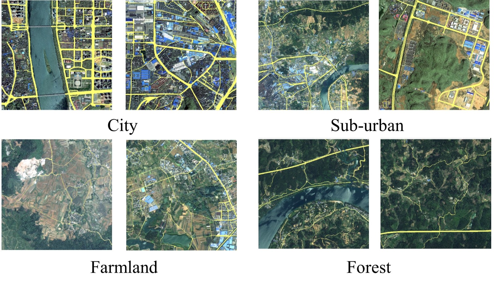
We manually annotated a satellite imagery dataset of roads in Southern China, termed the Wuhan University (WHU) Road Dataset (download from: http://www.lmars.whu.edu.cn/suihaigang/dataset). Images in our dataset are from a variety of satellites including Gaofen-II, WorldView-II and ZY-III, with a spatial resolution at 0.8–2 meters per pixel. Our dataset is located in Liuzhou City, Guangxi Province. The road region annotations in the WHU Road Dataset were labeled by experts in remote sensing image interpretation using ArcGIS software to ensure the quality of the dataset. In urban areas, road types including railways, motorways, primary roads, secondary roads, tertiary roads, and trunk roads were annotated. To simplify annotation, trivial roads such as footways in residential areas were ignored. In rural areas, we labeled roads wider than three meters and longer than five meters. Total area of valid data in our dataset is over 1145 km2. The WHU Road Dataset was cropped into image tiles with the size of 512*512 pixels, with a total number of 6828 samples.

Baidu Netdisk (https://pan.baidu.com/s/1UcyMBa8M-peHe8rDz3nRVA), password: WHUR
To verify the robustness of road extraction algorithms across region, three large images are also available for downloading. These images are located in three cities in China: Hezhou, Liuzhou, and Nanning. For reasons of privacy protection, the road markings of the three large images cannot be made public for the time being. If you need to evaluate the road extraction results on these three large images, you can email your road extraction results to mintyzhou@whu.edu.cn. Please set the pixel value of the road and the background to 255 and 0 respectively before sending your results. We will report the precision, recall, IoU, accuracy, and F1-score values of your results as soon as possible.
Please note that we do not own the copyrights to the large satellite images. Their use is RESTRICTED to non-commercial research and educational purposes.
If you use our dataset, please consider citing our work:
[1] Zhou M, Sui H, Chen S, et al. BT-RoadNet: A boundary and topologically-aware neural network for road extraction from high-resolution remote sensing imagery[J]. ISPRS Journal of Photogrammetry and Remote Sensing, 2020, 168: 288-306.
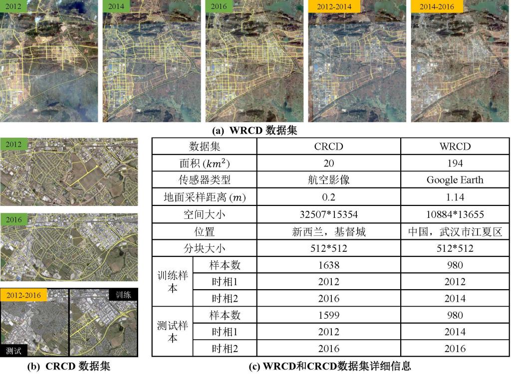
我们手动标注了两套道路变化检测与更新数据集,以评估基于多时相遥感影像的道路变化检测与更新方法的性能。第一个数据集位于新西兰基督城,命名为基督城道路变化检测 (Christchurch Road Change Detection, CRCD) 数据集。 CRCD数据集中的双时相遥感影像是下载于网站http://study.rsgis.whu.edu.cn/pages/download/building_dataset.html 的航空影像,采集时间分别为2012年和2016年。第二套数据集位于中国武汉市的江夏区,命名为武汉道路变化检测 (Wuhan Road Change Detection, WRCD) 数据集。WRCD数据集的遥感影像是从 Google Earth上下载的17级遥感影像,获取时间为 2012、2014 和 2016 年。WRCD 和 CRCD 数据集的详细介绍如下图所示。

[Baidu Netdisk](https://pan.baidu.com/s/13OKNkuny7gVsJaeRdJCL1w?pwd=e6s0, password: 06aa
If you use our dataset, please consider citing our work:
[1] Zhou, M., Sui, H., Chen, S., Chen, X., Wang, W., Wang, J. and Liu, J., 2022. UGRoadUpd: An Unchanged-Guided Historical Road Database Updating Framework Based on Bi-Temporal Remote Sensing Images. IEEE Transactions on Intelligent Transportation Systems, 23(11), pp.21465-21477.